Easy to use outdoor navigation app with free access to the best available maps and aerial imagery for the USA. Choose between 30+ map layers (topos, aerials, sea charts) to plan the perfect trip and turn your Andoid Phone/Tablet into an outdoor GPS for offline trips into the backcountry.
 |
 |
US Topo Maps are designed to be highly accurate and provide a wealth of information about the natural and man-made features of an area. They depict contour lines that represent changes in elevation, allowing users to understand the terrain and plan outdoor activities like hiking, camping, or mountaineering. The maps also showcase water bodies such as lakes, rivers, and streams, as well as vegetation, roads, trails, and points of interest.
One notable feature of US Topo Maps is their digital format. While traditional topographic maps were typically printed on paper, US Topo Maps are available in a digital format that can be accessed and viewed on various devices, including computers, smartphones, and GPS devices. This enables users to easily access and navigate the maps, zoom in on specific areas, and overlay additional data or information.
Available basemap layers for USA:
- USGS National Map Topo
- USGS National Map Imagery Topo
- USGS National Map Imagery
- USGS NAIP HiRes Imagery
- USGS Topo traditional DRGs: Seamless coverage of topo maps of the USA at Scales 1:250.000, 1:100.000, 1:63.000 and 1:24.000/25.000
- FSTopo Forest Maps
- NOAA Nautical RNC Charts
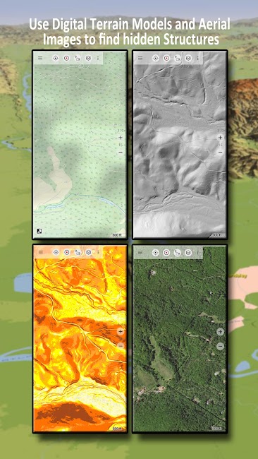
- National Elevation Maps (Hillshade, Slope Map, Aspect Map)
Main features for outdoor-navigation
- Download map data for OFFLINE USAGE
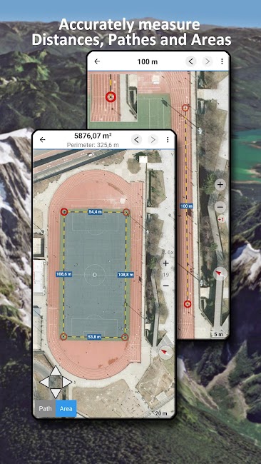
- Measure pathes and aereas
- Create and edit Waypoints
- GoTo-Waypoint-Navigation
- Create and edit Routes
- Route-Navigation (Point-to-Point Navigation)
- Track Recording (with speed, elevation and accuracy profile)
- Tripmaster with fields for odometer, average speed, bearing, elevation, etc.
- GPX/KML/KMZ Import/Export
- Search (placenames, POIs, streets)
- Get elevation and distance
- Customizable datafields in Map View and Tripmaster (e.g. Speed, Distance, Compass, ...)
- Share Waypoints, Tracks or Routes (via eMail, Dropbox, WhatsApp, ..)
- Use coordinates in WGS84, UTM or MGRS/USNG (Military Grid/ US National Grid), What3Words• Track Replay
- and many more ...